
RF Map AU - open-data and the cloud
March 26, 2014
Software-defined radio
I’m naturally very curious about the way the world works, and I’ve always been fascinated by electronics - when I was much younger I used to spend my spare time soldering together electronic components in kits purchased from DickSmith. At one stage, taking apart an old amplifier, (much to my parents horror) I accidentally electrocuted myself and had to spend a night in hospital under observation. Needless to say I learned some things the hard way!
Anyway - one thing that always fascinated me was the concept of radio-frequency electronics - that there were these invisible radio waves all around us that allowed information to be sent over the air.
The history of radio is very interesting in itself - something I won’t go into here - but a few years ago I came across some videos showing how a linux kernel developer discovered that a cheap ($20) USB TV Tuner could be used to receive FM radio - where most of the processing was done in software.
Now aside from the sheer-geekery of all this - I think software defined radio is incredibly important because it allows companies developing hardware components to reduce their prototype and iteration times - hugely important for effective product innovation.
There is also the education aspect of SDR - because there is a bunch of open-source software which makes learning RF engineering alot of fun, I think it puts this kind of stuff into the realm of high-school science experiment instead of university level engineering degree.
ACMA RadCom Register
So what has all this got to do with open-data? Well the Australian Communications and Media Authority publishes a Register of Radiocommunication Licenses that shows all licensed radio communication sites in Australia. To be fair, their search interface isn’t that bad
- but it is a bit slow if you zoom out, and it often seemed to give an error of “Too many sites to display - zoom in further or use a more selective filter.”
Well ACMA publishes the full dataset on CD. The license they provide the data under is pretty good - its not ‘creative commons’ but it does allow for full derivate works to be made, with a caveat that forbids spamming the license holders.
Other people have had the same idea, of course - one well known site is the [Australian Geographical RadioFrequency Map] (http://maps.spench.net/rf/) built by Balint Seeber. It’s pretty good, but again it suffers from the problem that it doesn’t scale that well - the data is hosted in on a single server.
Wouldn’t it be great if we could easily put this sort of geographic information in the cloud?
The power of the cloud
I recently stumbled across Google Maps Engine - Google’s Enterprise product that allows businesses to harness the technology behind Google Maps.
I signed up and literally within a few hours was able to upload the site locations from a CSV file onto Google Map Engine, style the layers and publish the data.
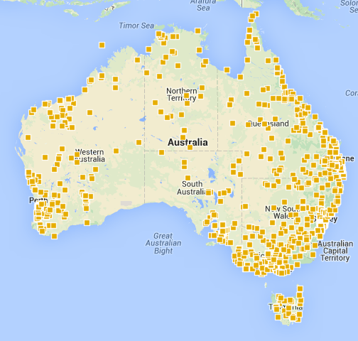
The result is impressive. I’ve got a few other ideas planned for this data (perhaps involving a D3js visualisation) so will post here when they’ve come to fruition.
This might sound like a sales pitch for Google - I am a big fan of their cloud platform (I use Google App Engine extensively) - but it’s not meant to be a sales pitch for Google - rather my point is more that open-data drives innovation in use of that data for service delivery.